
The blue area is the Philippine Sea. To its left is the Philippine Islands.

Can you visualize the location of the Philippine Sea within the vast Pacific Ocean? The long elongated island to the extreme middle left is The Philippines.
Philippine Sea is a section of the western North Pacific, lying east and north of the Philippines. The floor of this portion of the ocean is formed into a structural basin by a series of geologic folds and faults which protrude above the surface in the form of bordering island arcs.
The Philippine sea is bounded as follows:
On the southwest by The Philippine islands of Luzon, Samar and Mindanao
On the southeast by Palau, Yap and Ulithi of the Carolines
On the east by the Marianas, including Guam, Saipan and Tinian
On the northeast by the Bonin and Volcano islands (Iwo Jima)
On the north by the Japanese islands of Honshu, Shikoku and Kyushu
On the northwest by the Ryukyu Island (Okinawa)
On the extreme west by Taiwan (Formosa)
They surround an area about 3 percent of the entire Pacific region. This basin plunges to its greatest depths in trenches to the east of the island arcs.
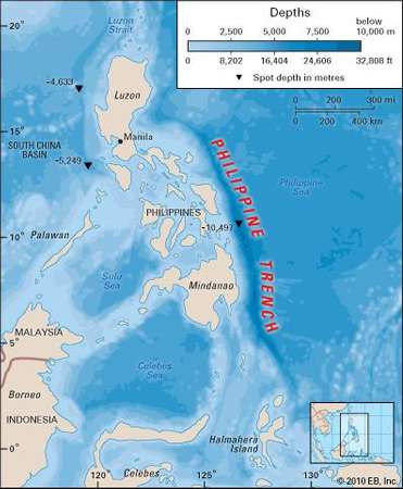
The deepest is the Philippine Trench also called Philippine Deep, Mindanao Trench, or Mindanao Deep, a submarine depression in the Philippine Sea section of the western North Pacific Ocean bordering the east coast of the island of Mindanao. It reaches the second greatest depth known in any ocean.
The abyss was plumbed in 1927 by the German ship “Emden”. The 35,410 ft (10793 m) reading obtained at that time (later corrected to 34,578 ft was the first indication of the actual near-record depth of the deep.
In 1945, the USS “Cape Johnson” reached 34,440 ft, slightly exceeded by the 34,578 ft sounding originally made by the Danish “Galathea” in 1951.
Later soundings reported to exceed these have been found to be instrumentation errors. There are numerous seamounts (mountains) rising from the basin floor, some of which are volcanic with their peaks, often flat called tablemount or guyots capped with coral.
The first European to navigate the Philippine Sea was Ferdinand Magellan in 1521 who named it Mar Filipinas when he and his men were in the Mariana Islands prior to the exploration of the Philippines. Later it was discovered by other Spanish explorers from 1522 to 1565 and the site of the famous galleon trade route.
For fans of WWII in the Pacific, during World War II, the U.S. Navy’s Pacific fleet achieved two significant victories over the Japanese combined fleet in the southern Philippine Sea.
The first, which took place west of the Marianas and came to be known as the Battle of the Philippine Sea, was fought entirely by carrier-based planes between Japan and the United States on June 19-20, 1944, seventy-five years ago. The aerial part of the Battle of the Philippine Sea was nicknamed the “Great Marianas Turkey Shoot” due to the massive losses of Japanese aircraft and pilots.
The second encounter, known as the Battle of Leyte Gulf on Oct. 23-26, 1944 which involved the major units of both fleets and was a decisive American victory.
Sources:
Encyclopedia Britannica

Reblogged this on Rosalinda R Morgan.
LikeLike
Thank you for keeping up with such detailed information about the P.I. history, Rose. You do a wonderful job!
LikeLiked by 1 person
You’re welcome GP! Thank you. I enjoy doing it.
LikeLiked by 1 person